Finding your space
Digital mapping and geolocation have become critical to battlespace users, and ensuring the best content is delivered is vital.


This article is brought to you by Systematic
The move from paper-based maps with basic legends covering terrain features to easily portable digital devices complete with satellite imagery has allowed military forces the ability to know the lie of the land more easily. In combination with GIS tools that can convey critical information, such as line-of-sight and structured data, troops on the ground can achieve their aims with a greater degree of security and certainty.
What can be the game-changer for these mapping tools is the addition of data overlays. As the modern mission environment now allows for the rapid dissemination and communication of intelligence, the delivery of information such as friendly and enemy force dispositions, type, and capability now allows military forces to understand the battlespace better. This can be further enhanced by the addition of other geospatial data, such as communications capabilities and coverage, electronic warfare reception and interference, infrastructure locations and transportation nodes, weather and environmental conditions, and more.
Delivering overlay data with additional intelligence enriches the understanding of the operating environment and moves the comprehension of the battlespace away from the immediate surroundings and into the wider vicinity. As a result, it is possible to take advantage of an opponent’s weaknesses or identify your own areas of vulnerability.
Delivering more than a map symbol
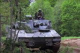
Understanding what is behind a map symbol can make the difference between a successful manoeuvre, and one that struggles to succeed. Where a map symbol may show an enemy tank, understanding what kind of tank it is can give friendly forces an appreciation for its potential capabilities – from sensors and their detection abilities, to armament ranges, and armour protection. As such, on-the-ground commanders can assess a threat, and how to engage with it.
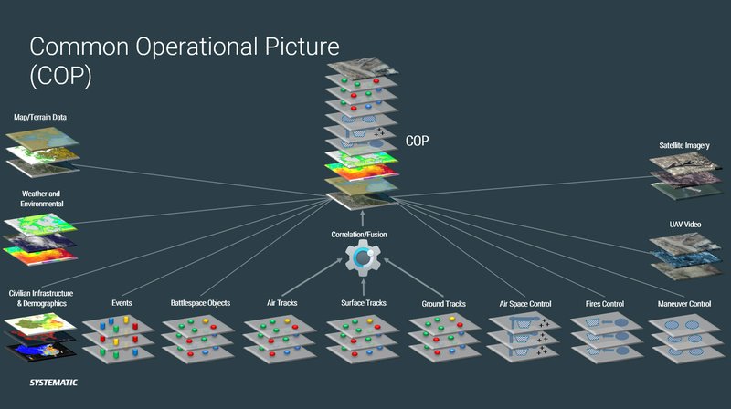
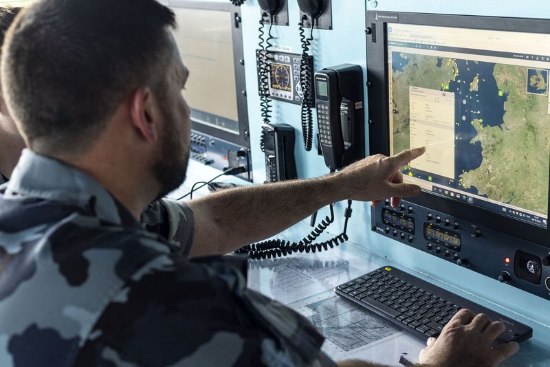
SitaWare Headquarters users are able to attach video snapshots to symbols on the common operational picture (COP), allowing for greater situational awareness around the status of an asset. For enemy assets, this can allow a battlefield commander to gain an understanding of its capabilities and formation, as well as condition.
Friendly forces are also able to understand the capabilities and holdings of friendly teams, communicate easily through direct chat networks, and work together to develop and deliver plans for missions – giving more data than just a map symbol. This work can be done by both mounted and dismounted commanders using SitaWare Frontline and SitaWare Edge, respectively, with the disposition of forces on the map being refreshed regularly to improve situational awareness.
Spatial intelligence
Spatial awareness tools can bring further depth to a battlespace map. SitaWare Headquarters features a range of tools to help commanders and planners achieve their mission goals though improved spatial awareness and intelligence of enemy positions.
Line-of-sight tools allow commanders to see the true reach of a weapon or sensor system, accounting for topography and structural blocks to highlight blind spots and fields-of-fire. This can help commanders best position their own assets or understand the best path of approach for troops engaging an enemy position.
Similarly, SitaWare Headquarters users can add range domes to known systems – enabling planners to operate in areas out of detection or range of enemy weapons and sensors when approaching a target. Knowing the blind spots of these sensors can reduce the chance of detection, increase the likelihood of mission success, and enable SitaWare users to get ahead of an enemy’s decision-making cycle.
Fusing tracks for intelligent decisions
As the number of sensors on the battlefield proliferates, the risk of duplication also increases. Creating an accurate COP that takes account of the multiple data sources can ensure that the best level of situational awareness is delivered in as close to real-time as possible.
The SitaWare suite of products can leverage artificial intelligence to help fuse data points together, allowing for better detection redundancy, in addition to providing forecasts of a target’s potential direction of travel. This can cover the location of vessels above and below the waterline, as well as vehicles transiting the land environment.
Artificial intelligence can also be used to identify patterns-of-life by civilian and military actors in the battlespace, allowing commanders to spot anomalies, or identify pre-attack activity. These applications of artificial intelligence help to bring intelligence to the data points behind the map symbols, and mean that commanders can get ahead of an opponent’s ‘OODA loop’.
Future pitfalls
Challenges within this digital battlespace representation abound. Tactical and strategic electronic warfare can disrupt the positioning, navigation, and timing data that is necessary to accurately track friend and foe alike. Spoofing of identification signals, such as shipborne AIS, can also be done to disguise the location, history, and intentions of a civilian or military vessel. Looking to the future, as the cyber domain becomes more readily exploited, an actor could use cyber and information warfare to overwhelm a system with false data, or subtly add, remove, or alter the properties of an element in the COP.
As the operational art and doctrine around information warfare operations become more entwined with multidomain operations, the ability to disrupt and be disrupted is increasing. Deploying a cyber-assured solution that can withstand cyberattack will help ensure that commanders retain the ability to direct their forces with confidence. The SitaWare suite has, for example, received Cybersecurity Tools certification from the US Department of Defense’s Defense Information Systems Agency (DISA) – proving its capabilities to continue operating under conditions of cyberattack.


More from Industry Spotlights
-
![MKJ Warrior Series — The Nett Warrior Qualified Connector for Today’s Soldier Systems]()
MKJ Warrior Series — The Nett Warrior Qualified Connector for Today’s Soldier Systems
ITT Cannon’s MKJ Warrior connectors are designed for the harshest environments, delivering mission critical comms, navigation and USB data/power.
-
![“Dramatic leaps in processing capability”: how GDMS–UK is evolving mission systems for the modern battlespace]()
“Dramatic leaps in processing capability”: how GDMS–UK is evolving mission systems for the modern battlespace
In Conversation... Shephard’s Gerrard Cowan talks to Sam Steggall, GDMS–UK’s Senior Director – Air and Naval UK, about the company’s extensive and proven in-country capability to deliver complex avionics solutions and its key role on major Royal Air Force and Royal Navy aircraft programmes.
-
![The future is here: Sixth-gen air dominance]()
The future is here: Sixth-gen air dominance
How RTX is equipping the military airspace – for today’s fleet and tomorrow’s fight.
-
![De-Risking the Future: Manufacturing Certainty for Unmanned Systems]()
De-Risking the Future: Manufacturing Certainty for Unmanned Systems
How strategic manufacturing partnership solves the industrialisation triad — Scale, Compliance and Cost — for hyper-growth defence tech innovators.
-
![Battlefield mobility, made in the UK]()
Battlefield mobility, made in the UK
How does Britain ensure that we can preserve the lives of our soldiers and allies – now and in the future – with homegrown innovation and resilient domestic manufacturing? At Pearson Engineering, we are proud to be a central part of the answer to this increasingly important question.
-
![Strengthening Baltic defence capabilities]()
Strengthening Baltic defence capabilities
How Latvia is bolstering its territorial defences, industrial capacity and international cooperation with Dynamit Nobel Defence’s SKORPION2 Remote Mining System.