
US Army, Lockheed Martin demonstrate MS GUI
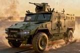
Lockheed Martin announced on 21 October that it had been selected by the US Army's Research Development And Engineering Command, Communications-Electronics Research, Development and Engineering Center to demonstrate an advanced slew-to-cue sensor system designed to provide greater situational awareness during route clearance and surveillance missions.
The demonstration will be for the organisation’s Night Vision and Electronic Sensors Directorate. It will involve the company’s Multi-sensor Graphical User Interface (MS GUI), demonstrated recently at AUSA Annual in Washington, DC. Lockheed Martin says that it is an affordable, backwards compatible upgrade kit for fielded Gyrocam systems currently deployed with the US Army and US Marine Corps.
MS GUI allows the operator to use a touch screen display capability to slew between reference cameras, such as the Driver's Vision Enhancer, and the Gyrocam Vehicle Optics Sensor System, to simultaneously search for potential threats while interrogating identified hazards on route clearance missions.
Under a cooperative research and development agreement with NVESD, Lockheed Martin will continue to enhance capabilities of the MS GUI system for use in various situational awareness applications, paving the way for the eventual fielding of the technology.
We are pleased to partner with NVESD to integrate MS GUI into the Gyrocam VOSS suite of capabilities to support route clearance missions,’ said Kennan Walker, business development manager in Lockheed Martin's Gyrocam Systems business. ‘By working together to meet the increasing demand for enhanced situational awareness, we are providing our warfighters with an advanced capability that detects, identifies and tracks insurgent threats from safe stand-off distances and significantly reduces operator fatigue.’


More from Digital Battlespace
-
![World Defense Show 2026: Northrop Grumman to present improved C2 management system]()
World Defense Show 2026: Northrop Grumman to present improved C2 management system
The Northrop Grumman Integrated Battle Command System is in service with Poland and the US Army with another 20 countries believed to have expressed an interest.
-
![Thales looks to boost DigitalCrew system through AI and human-machine teaming trials]()
Thales looks to boost DigitalCrew system through AI and human-machine teaming trials
The Thales DigitalCrew package, first unveiled at last year’s Defence IQ International Armoured Vehicles conference, is designed to merge imaging and apply a layer of decision-making and observation algorithms to support crew and other personnel.
-
![Babcock nears first customer for Nomad AI translation tool]()
Babcock nears first customer for Nomad AI translation tool
Nomad can provide militaries with real-time intelligence, saving critical time on the battlefield.
-
![AUSA 2025: Israel’s Asio Technologies to supply hundreds of improved Taurus tactical systems]()
AUSA 2025: Israel’s Asio Technologies to supply hundreds of improved Taurus tactical systems
Taurus operates alongside the Israel Defense Forces’ Orion system which supports mission management across tens of thousands of manoeuvring forces, from squad leaders to battalion commanders.
-
![AUSA 2025: Kopin pushes micro-LED plans as China moves faster]()
AUSA 2025: Kopin pushes micro-LED plans as China moves faster
The plan for the new displays follows fresh investment in Kopin’s European facilities by Theon and an order for head-up displays in fielded aircraft, with funding from the US Department of Defense.
-
![AUSA 2025: Persistent Systems to complete its largest order by year’s end]()
AUSA 2025: Persistent Systems to complete its largest order by year’s end
Persistent Systems received its largest ever single order for its MPU5 devices and other systems earlier this month and has already delivered the 50 units to the US Army’s 4th Infantry Division.


