Transform the real world complexity into a virtual one (sponsored)
VELOCITY 5D is a data agnostic solution that can rapidly create rich and immersive 3D environments from a wide range of GIS data.


This story is brought to you by Presagis.
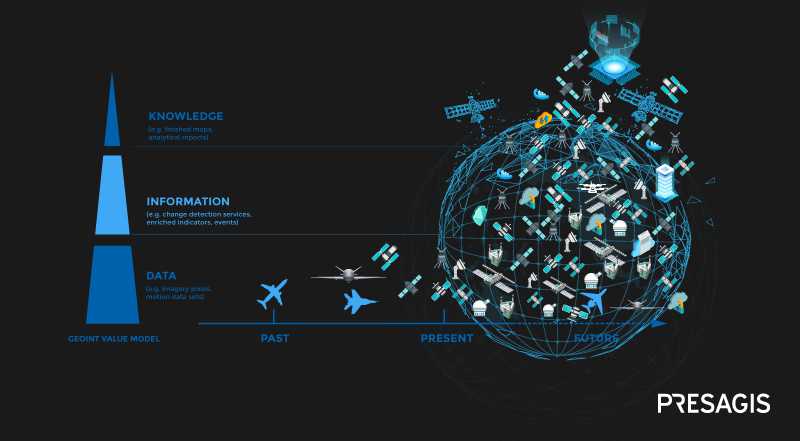
An explosion of data from a variety of devices and connected possibilities will see our world generate 10,000 times more data than already exists. Agencies, companies, and countries are consistently collecting more data than they can process and analyze – impacting the need for critical and complex decision making.
Whether for Defense, GeoINT, Infrastructure Management, or Utility sectors, these growing volumes of geospatial data are driving new requirements in data analytics, 4D visualization, urban terrain simulation and modeling.
VELOCITY 5D — or V5D — can examine all information, make it clean, organized and standardize the data to create a competitive advantage.
V5D is a software ecosystem that fundamentally changes the way in which users manage the production of digital twins and large virtual environments. V5D is able to exploit Big Data using:
• GIS data Extraction, AI processing and labeling, Multi-source Fusion and Inference to create instrumented data ready for simulation
• Continuous updates as new data becomes available
• Timeline - from historical data through present and future data (inferred or what-if scenarios)
• Data Distribution from local server to Cloud offering • Flexible and Customizable architecture to answer specific customer requirements
V5D was recently used in two case studies that demonstrates the power of the digital twin creation pipeline.
Case Study A: Worldwide Database
In 2020, Presagis participated in a project with a large US government agency to create a simulation-ready database (synthetic environment) of the entire planet with special emphasis on the continents of Asia, Europe, and North America. To accomplish this, Presagis used V5D. For training purposes, the client required both a global view of operations when flying at high altitudes, and high-resolution areas across the globe for when approaching an airport.
Project requirements consisted of gathering high-resolution satellite imagery, building footprints, roads, and vegetation to generate a high-quality simulation database. Depending on the type of area, the database specifications varied. For instance, global areas required medium resolution satellite imagery with some extra features, while specific areas of interest required high-resolution imagery with geo-specific content models in order to help pilots familiarize themselves with their surroundings – especially airports.
A manual process for this project would entail years of work, however, Presagis understood that in order to succeed with the scale and complexity of this project, an automated approach was required. The robustness of the V5D workflow reduced the delivery timeframe considerably, and permitted the rapid, automated creation of content. Moreover, many of the client’s existing workflows were re-used, thereby eliminating the need to create new procedures “from scratch” to generate a new CDB format database. Using V5D, the client was delivered generated content in hours instead of weeks or months.
Case Study B: Rapid Country-Wide Synthetic Environment
Presagis was tasked by a European Defense Ministry to process data and generate a synthetic environment of a 60,000 km2 European country. A GeoINT initiative from government officials requested an evaluation of V5D’s multiple advantages. The requirement was to complete the processing and generation of a large-scale virtual environment within 72 hours.
V5D demonstrated its capability to rapidly ingest new GIS data sources and create content for not only GeoINT, but for analysis generation in emergency management evaluation and response.
Presagis’ mandate included two cases:
- A. Creation of a CDB using available open sourced data (Imagery, Elevation, Trees and OSM buildings)
- B. Creation of a CDB using AI/ML algorithms (from the provided satellite imagery) to extract building footprints from the provided satellite imagery. This case is typically for when vector data has not been updated and requires information extraction.
Each case was completed in less time than required by the original mandate (72 hours), and with incredible results. V5D was able to generate the following for each case:
Case 1: CDB in 7.5 hours – Included ingestion of source data, processing and CDB creation.
Case 2: CDB total 68 hours – Included ingestion of source data, extraction of building footprints from satellite imagery using AI/ML, process and CDB creation. The V5D AI/ML Algorithm was able to extract 100k+ buildings compared to the OSM data in Case 1.
In using AI/ML feature extraction, V5D was able to extract approximately 100,000 more building footprints compared to Case 1, which used OSM data as source. Although the amount of additional buildings may seem minimal for an entire country, it is significant when considering the data was almost 8 years old. This means that the number of new buildings that could be extracted using more up-to-date imagery would be drastically increased.
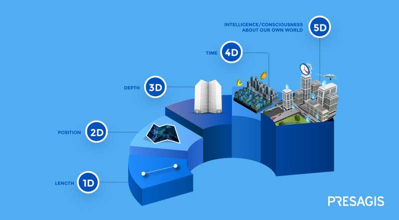
By combining best-of-bread tools with next generation architecture, V5D provides impressive performance in geo-localized content management. From 2D to 3D, users can seamlessly transform diverse GIS data streams into rich, multispectral environments, complete with pattern of life, humans, crowds, traffic, interactions, and behaviors. The result is a digital twin that delivers more than area, space, and time – it delivers the fifth dimension: context.
For more information click here.


More from Industry Spotlights
-
![The speed of relevance: how companies can navigate the new era of European defence procurement]()
The speed of relevance: how companies can navigate the new era of European defence procurement
European militaries face a rapidly evolving security landscape and defence production must accelerate to meet surging demand for platforms and equipment. Industry needs to adapt to ensure it gets its products into the hands of the end user, Evelyn Rafferty, Senior Director Aerospace and Defence - Europe at Plexus told Shephard’s Gerrard Cowan.
-
![Patria TRACKX: Designed to conquer the most challenging environments]()
Patria TRACKX: Designed to conquer the most challenging environments
The tracked all-terrain armoured vehicle Patria TRACKX is a promise of performance. It is engineered to navigate the toughest terrain silently and swiftly, ensuring smooth operations in any conditions.
-
![“A staggering rate of change”: how experience combating IEDs is being applied to the C-UAS arena]()
“A staggering rate of change”: how experience combating IEDs is being applied to the C-UAS arena
The scale of the current escalation in drone attacks is fuelling demand for C-UAS technology that must address a rapidly evolving and expanding threat. Against this background, important lessons can be learned from the battle against IEDs, with networked responses and dispersed capabilities essential to deliver enduring protection.
-
![Agile, sovereign, edge-ready: rewiring defence IT for a contested decade]()
Agile, sovereign, edge-ready: rewiring defence IT for a contested decade
Today's rapidly changing security landscape means that armed forces can no longer treat their data in the same way as in the past. What are the key challenges they face, and how can industry help them?
-
![The science of soldier safety: How Team Wendy Is reinventing the modern military helmet]()
The science of soldier safety: How Team Wendy Is reinventing the modern military helmet
When soldiers head into the field, the helmet on their head can mean the difference between life and death. But while helmets may look simple from the outside, the technology inside them is anything but. Few companies illustrate this better than Team Wendy, whose newest bump helmet — the RECON™ Tactical — shows just how far modern head protection has come.
-
![DVD2026: Connected for Combat]()
DVD2026: Connected for Combat
As the land equipment sector prepares for the premier biennial event at UTAC Millbrook on 16 and 17 September 2026, the narrative for this year’s exhibition has officially been set: Connected for Combat - Aligning People, Systems and Decisions.