Thales to incorporate Esri Geospatial Technology into C4I solutions
The latestgeospatial technology from Esri will be embedded into Commander, the Thales integrated C4I suite, Esri announced today.
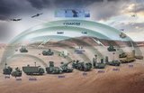
Integrated in Thales' communications and information framework, Esri software will improve operational services for defense users and provide complete geospatial solutions for integrated command, control, communications, computers, and intelligence (C4I) systems. The advanced battlespace display and analysis features will provide highly accurate, shared situational awareness and better decision support tools.
With Esri technology, defense users who have little or no experience working with geospatial software will be able to exploit geospatial information from maps, imagery, and sensors that commanders can then use for making decisions.
"This technical and operational partnership will truly leverage NATO and other military and commercial standards for interoperable C4I solutions for defense and security operations," said Jacques Rabain, vice president in charge of Protection Systems for Thales.
Comm@nder is the Thales family of integrated computerized C4I solutions. The suite's standardized and open architecture hosts tactical communications, network services, and operational information systems for a broad range of networkcentric defense and intelligence operations at the strategic, operational, and tactical levels. Defense users in NATO and several countries in Europe, Asia, and the Middle East use Comm@nder for C4I applications.
Esri provides geospatial capabilities to defense and intelligence organizations worldwide, including those behind the NATO Core Geographic Services (NCGS) project and the US Department of Defense (DoD) Commercial Joint Mapping Toolkit (CJMTK).
"Esri is honored to work with Thales, a global leader in C4I systems," said Jack Dangermond, Esri president. "Thales provides critical technology for defense and intelligence operations. We are pleased that the company has selected our geospatial technology to enhance its highly regarded Comm@nder suite."
Source: Esri


You may also like

More from Digital Battlespace
-
![Babcock nears first customer for Nomad AI translation tool]()
Babcock nears first customer for Nomad AI translation tool
Nomad can provide militaries with real-time intelligence, saving critical time on the battlefield.
-
![AUSA 2025: Israel’s Asio Technologies to supply hundreds of improved Taurus tactical systems]()
AUSA 2025: Israel’s Asio Technologies to supply hundreds of improved Taurus tactical systems
Taurus operates alongside the Israel Defense Forces’ Orion system which supports mission management across tens of thousands of manoeuvring forces, from squad leaders to battalion commanders.
-
![AUSA 2025: Kopin pushes micro-LED plans as China moves faster]()
AUSA 2025: Kopin pushes micro-LED plans as China moves faster
The plan for the new displays follows fresh investment in Kopin’s European facilities by Theon and an order for head-up displays in fielded aircraft, with funding from the US Department of Defense.
-
![AUSA 2025: Persistent Systems to complete its largest order by year’s end]()
AUSA 2025: Persistent Systems to complete its largest order by year’s end
Persistent Systems received its largest ever single order for its MPU5 devices and other systems earlier this month and has already delivered the 50 units to the US Army’s 4th Infantry Division.
-
![Aselsan brings in dozens of companies and systems under the Steel Dome umbrella]()
Aselsan brings in dozens of companies and systems under the Steel Dome umbrella
Turkey has joined the family of countries attempting to establish a multilayered air defence system with government approval in August 2024 for the effort landed by Aselsan. Dubbed Steel Dome, the programme joins Israel’s Iron Dome, the US Golden Dome, India’s Mission Sudarshan Chakra and South Korea’s low-altitude missile defence system.