
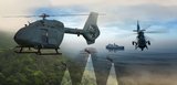
Raytheon's JLENS successfully tracks test targets
Raytheon Company's JLENS (Joint Land Attack Cruise Missile Defense Elevated Netted Sensor System) has successfully demonstrated tracking targets of opportunity in the Salt Lake City air space. Testing and integration of the system is being conducted at the Utah Test and Training Range.
This successful test follows a number of program milestones, including the first full-power transmit from the fire control radar. During previous testing at the Raytheon facility in Pelham, N.H., the radar successfully tracked targets of opportunity and ran planned flight tests for position verification.
"The JLENS program continues to demonstrate significant system maturity during real-world testing in Utah," said Dave Gulla, vice president, Global Integrated Sensors at Raytheon Integrated Defense Systems. "JLENS is a game-changing system for warfighters, providing enhanced situational awareness and surveillance capabilities in the detection and deterrence of cruise missile and unmanned aerial threats."
JLENS is the first aerostat platform featuring long-duration, wide-area, over-the-horizon detection and tracking of low-altitude cruise missiles and other threats. Additionally, its capabilities provide the battlefield commander with enhanced situational awareness and elevated communications, enabling sufficient warning to engage air defense systems and defeat threats.
"The JLENS team continues to meet significant program milestones, executing an aggressive test and training schedule," said Ken Gordon, program director, Raytheon's JLENS program. "The ongoing testing in Utah affirms our confidence in the system's technical maturity."
The fire control radar is one of two advanced, elevated sensor systems deployed on JLENS. The fire control radar performs wide area surveillance and precision tracking across the battlespace. It also provides combat identification and cues weapon systems to intercept threats at maximum ranges from defended assets.
Work on the JLENS program is performed at Raytheon sites located in Massachusetts, California, New Hampshire, Texas and Maryland. Raytheon IDS develops the fire control radar and processing station. Raytheon Space and Airborne Systems develops the surveillance radar. TCOM, L.P., based in Maryland, makes the aerostat and associated ground equipment.
Source: Raytheon


More from Digital Battlespace
-
![World Defense Show 2026: Northrop Grumman to present improved C2 management system]()
World Defense Show 2026: Northrop Grumman to present improved C2 management system
The Northrop Grumman Integrated Battle Command System is in service with Poland and the US Army with another 20 countries believed to have expressed an interest.
-
![Thales looks to boost DigitalCrew system through AI and human-machine teaming trials]()
Thales looks to boost DigitalCrew system through AI and human-machine teaming trials
The Thales DigitalCrew package, first unveiled at last year’s Defence IQ International Armoured Vehicles conference, is designed to merge imaging and apply a layer of decision-making and observation algorithms to support crew and other personnel.
-
![Babcock nears first customer for Nomad AI translation tool]()
Babcock nears first customer for Nomad AI translation tool
Nomad can provide militaries with real-time intelligence, saving critical time on the battlefield.
-
![AUSA 2025: Israel’s Asio Technologies to supply hundreds of improved Taurus tactical systems]()
AUSA 2025: Israel’s Asio Technologies to supply hundreds of improved Taurus tactical systems
Taurus operates alongside the Israel Defense Forces’ Orion system which supports mission management across tens of thousands of manoeuvring forces, from squad leaders to battalion commanders.
-
![AUSA 2025: Kopin pushes micro-LED plans as China moves faster]()
AUSA 2025: Kopin pushes micro-LED plans as China moves faster
The plan for the new displays follows fresh investment in Kopin’s European facilities by Theon and an order for head-up displays in fielded aircraft, with funding from the US Department of Defense.
-
![AUSA 2025: Persistent Systems to complete its largest order by year’s end]()
AUSA 2025: Persistent Systems to complete its largest order by year’s end
Persistent Systems received its largest ever single order for its MPU5 devices and other systems earlier this month and has already delivered the 50 units to the US Army’s 4th Infantry Division.


