EADS Defence & Security and Thales selected by DGA to supply Deployable Geographic Modules for French Army
EADS Defence & Security (DS) and Thales have received a contract worth 26.1 million euros from the French defence procurement agency DGA (Direction Générale de l'Armement) to produce and support two sets of MGPs (Modules Géographiques Projetables - deployable geographic modules) for the 28th Geographic Group of the French Army. The operation, for which DS has been designated prime contractor, aims to develop a system that is deployable and reactive in terms of production, maintenance and distribution of military geography information. The MGP modules will be used to supply geographic data updated in the field to operational land forces via a single cartographic access point.
Complementing the DNG3D (Données Numériques Géographiques et 3 Dimensions - 3D Digital Geographical Data) programme, which has developed systems in France for mass production of geographical information, the MGP modules will make it possible to enrich the data directly in external theatres. They can be used to provide an operational land force with appropriate geographical information in a reactive manner and in a timeframe that is compatible with operational requirements. In addition, they supply specialised support for decision-making by the General Staff.
EADS Defence & Security and Thales have elected to team up as co-contractors, in partnership with Magellium for its image-processing and geomatics know-how, Géo212 for its specialist expertise, and Euro Shelter for its mobile technical shelter know-how. On completion of the definition and production phase, DS and Thales will provide operational support for an initial period of six years. A prototype will be delivered by the end of the year and a complete MGP module is scheduled to be operational for use by the NATO Response Force (NRF) in 2012.
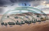
With the MGP modules, a veritable data production system will be employed in-theatre. Activities which until now have been restricted to France (SIG management, cartography, quality control, printing) will appear in-theatre, but with specific aspects related to the context of use: confined space, work under stressful conditions, large volumes of data to be stored and manipulated, reconfiguration capability. Used within the land forces, these modules will play a pivotal role in the provision of geographical data to satisfy as best as possible the following functions: geographical information gathering, source data transformation, product management and distribution to the forces.
Several modules can be deployed to different locations in the theatre of operations. Each module is autonomous and integrates all the equipment necessary to perform its mission (PCs, printers, storage units, etc.). The data that has been gathered can then be synchronised between the different modules and data consistency verified to produce maps that are fully up to date. This innovation will considerably change the operational forces' comprehension of their environment by enabling them to build up and manage a geographical knowledge base.
"This contract award illustrates the State's confidence in the capability of EADS Defence & Security (DS) to support the Army in its theatres of operations. DS' success in this project will confirm the group's determination to mobilise its know-how and experience in this particular domain of Military Geography and, more generally, in Intelligence, in accordance with the Defence White Paper," declared Hervé Guillou, CEO of Defence and Communications Systems (DCS).
"This project is the missing link between the production of geographical reference data in France and the end-users in-theatre, particularly the SIOCs (Systèmes d'Information Opérationnel de Commandement - operational command information systems), two areas in which Thales has been very active for a number of years. This entire chain, from data acquisition to data utilisation in the forces, contributes to global information control, which is one of the major issues for the Armed Forces Staff," added Pascale Sourisse, Thales Senior Vice-President in charge of C4I systems for defence and security.
The completed system will interconnect with the network of the SIC Terre (Systèmes d'Information et de Communications de l'armée de Terre française) Federation of French Army information and communications systems.
Source: EADS DS


You may also like

More from Digital Battlespace
-
![Babcock nears first customer for Nomad AI translation tool]()
Babcock nears first customer for Nomad AI translation tool
Nomad can provide militaries with real-time intelligence, saving critical time on the battlefield.
-
![AUSA 2025: Israel’s Asio Technologies to supply hundreds of improved Taurus tactical systems]()
AUSA 2025: Israel’s Asio Technologies to supply hundreds of improved Taurus tactical systems
Taurus operates alongside the Israel Defense Forces’ Orion system which supports mission management across tens of thousands of manoeuvring forces, from squad leaders to battalion commanders.
-
![AUSA 2025: Kopin pushes micro-LED plans as China moves faster]()
AUSA 2025: Kopin pushes micro-LED plans as China moves faster
The plan for the new displays follows fresh investment in Kopin’s European facilities by Theon and an order for head-up displays in fielded aircraft, with funding from the US Department of Defense.
-
![AUSA 2025: Persistent Systems to complete its largest order by year’s end]()
AUSA 2025: Persistent Systems to complete its largest order by year’s end
Persistent Systems received its largest ever single order for its MPU5 devices and other systems earlier this month and has already delivered the 50 units to the US Army’s 4th Infantry Division.
-
![Aselsan brings in dozens of companies and systems under the Steel Dome umbrella]()
Aselsan brings in dozens of companies and systems under the Steel Dome umbrella
Turkey has joined the family of countries attempting to establish a multilayered air defence system with government approval in August 2024 for the effort landed by Aselsan. Dubbed Steel Dome, the programme joins Israel’s Iron Dome, the US Golden Dome, India’s Mission Sudarshan Chakra and South Korea’s low-altitude missile defence system.