


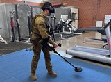
Cubic tailors mortar simulator for the US Army
The company’s mortar trainer received improvements based on soldier’s feedback.

MetaVR has released a new version of its Terrain Tools extension to the industry-standard Esri ArcGIS platform.
Terrain Tools 1.6 enables users to turn their geospatial data into real-time 3D terrain to render in the Virtual Reality Scene Generator image generator from MetaVR.
Terrain Tools combines ‘powerful 3D terrain building functionality with an accessible and intuitive interface that enables users to create real-time terrain for simulated military and civil training scenarios in MetaVR’s Metadesic round-earth terrain format’, the company noted in a 21 September statement.
Using Terrain Tools 1.6, MetaVR has already built a new high-resolution 3D terrain dataset of Spain (pictured), including Los Llanos Albacete Air Base in the centre of the country.
As part of our promise to deliver comprehensive coverage to our Defence Insight and Premium News subscribers, our curated defence news content provides the latest industry updates, contract awards and programme milestones.


The company’s mortar trainer received improvements based on soldier’s feedback.

The company will operate in two new locations in the coming years to better support US services.

This type of tool provides more realistic training easing the incorporation of new scenarios that accurately represent the threats of the battlefield.
The Engineering Corps has been conducting individual instruction using FLAIM Systems’ Sweeper and should start collective deployments in 2025.

The next-generation platform is motion-compatible and can be used in OTW and NVG applications.

The system can be used to prepare soldiers for both drone offensive operations and CUAS missions.

Connect with us on socials


