
Northrop Grumman announces new CIP capability
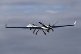
Northrop Grumman’s Common Imagery Processor (CIP) has demonstrated the ability to process Global Hawk Block 40 data on the Distributed Common Ground System – Imagery (DCGS-I) testbed. This marks the first time that Global Hawk Block 40 data has been successfully received, processed and disseminated on the DCGS-I testbed using the CIP.
The capability was demonstrated during a live flight event in late 2012, which saw the Global Hawk transmit the newest Block 40 concurrent modes data to the testbed. The CIP then processed and transmitted this data to other downstream ground station components for viewing and exploitation.
As the primary sensor processing element of the DCGS-I testbed, the CIP accepts airborne imagery data, processes it into an exploitable image and then outputs the image to other elements within the testbed. The CIP is the standard image processor used by the US Department of Defense (DoD). The CIP also helps coalition partners to consolidate redundant and stovepiped processing systems.
The CIP's latest software allowed for the newest synthetic aperture radar (SAR) imagery mode to be processed while simultaneously passing the ground moving target indicator data on to another system for processing. The CIP is the only platform capable of processing concurrent SAR data.
Ed Bush, vice president of Northrop Grumman's C4ISR Networked Systems business unit, said: ‘Northrop Grumman continually provides soldiers an upper hand through the CIP's innovative imagery capabilities that process images quickly and efficiently. Additionally, the programme reflects our open architecture approach and quick fielding of integrated software-based systems through the use of commercial and government off-the-shelf components.’
The CIP has been involved in numerous integration and test activities for many platforms and sensors. Since 2000, the CIP has applied its critical ability to ingest data via the Common Data Link to serve as the main imagery processor of the DCGS-I testbed. The DoD uses the DCGS-I testbed to evaluate new intelligence, surveillance and reconnaissance technologies in an operational environment. The testbed has been an active participant in ongoing block upgrades for the Northrop Grumman-developed Global Hawk unmanned aircraft.


More from Digital Battlespace
-
![World Defense Show 2026: Northrop Grumman to present improved C2 management system]()
World Defense Show 2026: Northrop Grumman to present improved C2 management system
The Northrop Grumman Integrated Battle Command System is in service with Poland and the US Army with another 20 countries believed to have expressed an interest.
-
![Thales looks to boost DigitalCrew system through AI and human-machine teaming trials]()
Thales looks to boost DigitalCrew system through AI and human-machine teaming trials
The Thales DigitalCrew package, first unveiled at last year’s Defence IQ International Armoured Vehicles conference, is designed to merge imaging and apply a layer of decision-making and observation algorithms to support crew and other personnel.
-
![Babcock nears first customer for Nomad AI translation tool]()
Babcock nears first customer for Nomad AI translation tool
Nomad can provide militaries with real-time intelligence, saving critical time on the battlefield.
-
![AUSA 2025: Israel’s Asio Technologies to supply hundreds of improved Taurus tactical systems]()
AUSA 2025: Israel’s Asio Technologies to supply hundreds of improved Taurus tactical systems
Taurus operates alongside the Israel Defense Forces’ Orion system which supports mission management across tens of thousands of manoeuvring forces, from squad leaders to battalion commanders.
-
![AUSA 2025: Kopin pushes micro-LED plans as China moves faster]()
AUSA 2025: Kopin pushes micro-LED plans as China moves faster
The plan for the new displays follows fresh investment in Kopin’s European facilities by Theon and an order for head-up displays in fielded aircraft, with funding from the US Department of Defense.
-
![AUSA 2025: Persistent Systems to complete its largest order by year’s end]()
AUSA 2025: Persistent Systems to complete its largest order by year’s end
Persistent Systems received its largest ever single order for its MPU5 devices and other systems earlier this month and has already delivered the 50 units to the US Army’s 4th Infantry Division.


