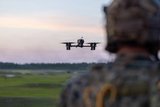
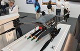
AeroVironment unveils Quantix Recon


AeroVironment on 23 April launched a military variant of its Quantix crop-surveying UAV.
Quantix Recon is a fully-automated hybrid VTOL UAS, designed to deliver high-resolution georeferenced aerial imagery on demand for mission planners on their tablets.
Its RF silent mode enables Quantix Recon to conduct missions undetected, AeroVironment stated.
Quantix Recon surveys up to 1.6 km2 or 20km on a linear flight path per 45-minute single battery flight. Multiple automated reconnaissance mode options allow users to choose between line, area and waypoint targeted data capture.
The UAV operates a five optional altitudes from 150-800ft. Collected aerial imagery data is compatible with a wide range of available geographic information system (GIS) tools to facilitate further analysis.
Rick Pedigo, VP of sales and business development for AeroVironment, said: ‘Because it does not rely on radio signals during flight, Quantix Recon offers greater stealth for concealed operations and is unaffected by radio frequency jammers, providing greater protection for frontline troops while reducing cognitive load.’
Related Equipment in Defence Insight


More from US Military Aviation Special Report
-
![US Army ahead of ITEP schedule despite CDR delay]()
US Army ahead of ITEP schedule despite CDR delay
The Critical Design Review (CDR) phase of the US Army's Improved Turbine Engine Programme (ITEP) has been delayed by two weeks because of COVID-19 issues. …
-
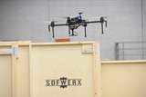
![SOF seeks integration help to counter unmanned aircraft]()
SOF seeks integration help to counter unmanned aircraft
US Special Operations Command (USSOCOM) is seeking industry white papers for its C-UAS Systems Integration Partner (CUxS SIP) requirement. In an RfI published on 17 April, USSOCOM …
-
![Fire Scout set to gain Link 16]()
Fire Scout set to gain Link 16
Northrop Grumman is set to receive new contracts from the US Navy over the next two years to integrate Link 16 on the MQ-8C Fire …
-
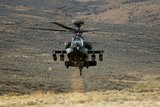
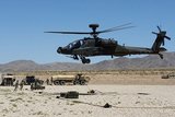
![US Army counts down to AH-64E V6 operations]()
US Army counts down to AH-64E V6 operations
The US Army will aim to have the new AH-64E Apache Guardian V6 configuration in service during Q1 2022 following flight training with the first …
-
![U-2 Dragon Lady shows plenty of life]()
U-2 Dragon Lady shows plenty of life
A popular phrase in the US is ‘if it ain’t broke, don’t fix it’. In aviation, one could think of the DC-3 and the 747, …
-
![COVID-19 poses practical and strategic questions for US air power]()
COVID-19 poses practical and strategic questions for US air power
The COVID-19 coronavirus pandemic has changed just about everything, including US air power. The effects are likely to be felt for years, including a downturn …