
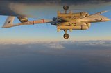
GeoDragon sensor system integrated with T-20 UAV


A sensor system that can create 2D and 3D images in near real time has been flown on the T-20 Tier II unmanned aerial vehicle (UAV) for the first time. The sensor, called the GeoDragon system, has been developed by Urban Robotics, and will be released in mid-2014.
The GeoDragon system can create 3-D reconstructions in near-real time and output high-resolution digital elevation models, LIDAR-like datasets, and wide area maps. The system is enclosed in a wing-mounted pod, and will bring significant mapping capabilities to the T-20 UAV.
GeoDragon imagery is post-processed using automated 3-D algorithms to rapidly generate large mapping and modelling datasets.
The T-20, built by Arcturus UAV, is a runway independent, Tier II class, small tactical UAV with a technical readiness level (TRL) 9. The primary mission of the Arcturus UAV is intelligence, surveillance and reconnaissance. Typical missions include aerial mapping, drug interdiction, fire-fighting, border patrol, force protection, search and rescue, as well as military ISR.
The T-20 can also carry EO/IR payloads simultaneously with the GeoDragon. An onboard GPS autopilot with waypoint navigation accepts multiple flight plans from the Ground Control Station, allowing the T-20 to return to a specified location autonomously after up to 16 hours of flight. The UAV is powered by a 190cc an air-cooled, four-stroke, fuel injected engine; and the carbon fibre composite construction used in the T-20 airframe allows for payloads up to 65 lbs.


More from Uncrewed Vehicles
-
![The shift away from Chinese drone technology presents supplier opportunities]()
The shift away from Chinese drone technology presents supplier opportunities
As countries increasingly move away from Chinese drone manufacturing and focus on domestic production and collaboration, Europe and the US are well-placed to step in – although cost remains a crucial consideration.
-
![What’s next for the Pentagon after the Replicator programme?]()
What’s next for the Pentagon after the Replicator programme?
Although the Replicator initiative has made several accomplishments, there are still multiple gaps to plug across the US Department of Defense (DoD) and its services.
-
![Cummings Aerospace showcases Hellhound loitering munition designed for US Army’s LASSO programme (video)]()
Cummings Aerospace showcases Hellhound loitering munition designed for US Army’s LASSO programme (video)
Cummings Aerospace presented its turbojet-powered Hellhound loitering munition at SOF Week 2025, offering a man-portable solution aligned with the US Army’s LASSO requirements.
-
![SOF Week 2025: PDW unveils attritable FPV drone for SOF operations at scale]()
SOF Week 2025: PDW unveils attritable FPV drone for SOF operations at scale
PDW has revealed its Attritable Multirotor First Person View drone at SOF Week 2025, offering special operations forces a low-cost, rapidly deployable platform for strike and ISR missions, inspired by battlefield lessons from Ukraine.
-
![SOF Week 2025: Teledyne FLIR white paper provides guidance on reusable loitering munitions]()
SOF Week 2025: Teledyne FLIR white paper provides guidance on reusable loitering munitions
Teledyne FLIR is highlighting the emerging requirements for 'recoverable and re-usable' loitering munitions across the contemporary operating environment during this week’s SOF Week conference in Tampa, Florida.
-
![SOF Week 2025: Kraken Technology group debuts K3 Scout USV in North America]()
SOF Week 2025: Kraken Technology group debuts K3 Scout USV in North America
High-performance maritime industry player Kraken Technology Group, based in the UK, has used the SOF Week conference in Tampa, Florida this week to debut its K3 Scout uncrewed surface vessel (USV) to the North American market.


