


US Navy foresees an uncrewed future for its surface and underwater fleet
The service has been conducting various procurement and development efforts to integrate unmanned surface and underwater vehicles into its inventory.

Bluesky has launched a fast response aerial survey service using unmanned aerial vehicles (UAV) or drones. The technology, originally developed by the military, includes Artificial Intelligence (AI) guided autopilot, high resolution integrated camera and environmentally friendly rechargeable propulsion system, the company said in a 23 May, 2012 statement.
Potential applications of Bluesky's UAV solution include open cast mines or quarries or even landfill sites where large volumes of material are extracted or moved on a regular basis. The geographically accurate imagery would provide a record of activity at a given point in time and the highly detailed height models could be used to measure stockpiles, cut and fill volumes and for facilities management and safety monitoring. Autonomous take-off and landing ensures the system is easy to use and with a wingspan of less than a metre it can be transported without the need for complex assembly.
Large scale construction sites can also be surveyed, at regular intervals or predetermined points in time, providing data for project management, reporting and funding, the company said. The height data can be used for line of site calculations to ensure compliance with planning applications or cut and fill calculations for project invoicing and for the creation of realistic 3D images for marketing or KPI reporting.


The service has been conducting various procurement and development efforts to integrate unmanned surface and underwater vehicles into its inventory.

Tekever has manufactured the AR3, AR4 and AR5 UAS with all systems sharing common electronics and software architecture, which has enabled the reuse of ground segment elements within the new ARX UAS.
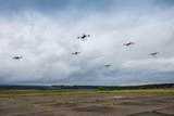
As the dynamics of aerial combat rapidly evolve, Chinese scientists have engineered a sophisticated air separation drone model that can fragment into up to six drones, each capable of executing distinct battlefield roles and challenging the efficacy of current anti-drone defences such as the UK’s Dragonfire laser system.
Advancements in air defence technologies have begun to reshape aerial combat dynamics in the Middle East, as illustrated by recent events involving the Israeli Air Force and Hezbollah.

Both sides of the Russia-Ukraine war have been using UAS for effective low-cost attacks, as well as impactful web and social media footage. Thousands more have now been committed to Ukrainian forces.
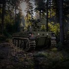
The US Army has intentions to develop light, medium and heavy variants of the Robotic Combat Vehicle (RCV) as part of the branche’s Next Generation Combat Vehicle family.

Connect with us on socials


