
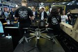
Weaver selects UX11 UAV for surveying and mapping


Weaver Consultants Group has selected Delair’s UX11 unmanned aerial vehicle to assist with its large-scale volumetric surveying and topographic mapping.
Commercial UAV manufacturer Delair along regional reseller Seiler Instrument, announced that the engineering firm had selected the UAV, which will initially be used to develop digital versions of its clients’ sites – mainly large disposal and landfill operations – and perform regular volume calculations to assist in managing the land use at those sites.
The Delair UAV gives the Weaver team an efficient way to cover large areas quickly, the company says, and provides them with precision data, including detailed images, as well as environmental information needed to monitor their operations.
‘For the large areas we need to cover, a fixed-wing drone makes sense,’ Kurt Aper, unmanned aerial team lead at Weaver, said.
‘We can cover a lot of ground in a short amount of time – we can do three or four 45min flights per day and get reasonably high-resolution data, even flying at 234ft. We can do 900 acres in a day and there’s no way we could do that with rotor style drones, much less by foot.’
Aper noted that a project of more than 40 acres is roughly the threshold where the real benefits of a fixed-wing UAV such as the UX11 become apparent.
The Delair UAV is becoming a critical tool for them as they help landfill developers and operators precisely estimate the volume of materials that are filling their sites, and develop expansion plans, the company added.
Seiler Instrument and Delair field support teams worked alongside Weaver’s surveying team to evaluate the Delair system to ensure it met the firm’s requirements, including integration with other tools the firm uses such as AutoCAD, Trimble Business Center, and the Pix4D photogrammetry suite.
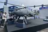
The Delair UX11 UAV was introduced commercially last year, and is one of the company’s top-of-the-line systems.
The fixed-wing aircraft provides accurate images for survey-grade mapping, with on-board processing capabilities and real-time, and long-range control via 3G/4G cellular networks or radio links.
Related Equipment in Defence Insight


More from Uncrewed Vehicles
-
![The shift away from Chinese drone technology presents supplier opportunities]()
The shift away from Chinese drone technology presents supplier opportunities
As countries increasingly move away from Chinese drone manufacturing and focus on domestic production and collaboration, Europe and the US are well-placed to step in – although cost remains a crucial consideration.
-
![What’s next for the Pentagon after the Replicator programme?]()
What’s next for the Pentagon after the Replicator programme?
Although the Replicator initiative has made several accomplishments, there are still multiple gaps to plug across the US Department of Defense (DoD) and its services.
-
![Cummings Aerospace showcases Hellhound loitering munition designed for US Army’s LASSO programme (video)]()
Cummings Aerospace showcases Hellhound loitering munition designed for US Army’s LASSO programme (video)
Cummings Aerospace presented its turbojet-powered Hellhound loitering munition at SOF Week 2025, offering a man-portable solution aligned with the US Army’s LASSO requirements.
-
![SOF Week 2025: PDW unveils attritable FPV drone for SOF operations at scale]()
SOF Week 2025: PDW unveils attritable FPV drone for SOF operations at scale
PDW has revealed its Attritable Multirotor First Person View drone at SOF Week 2025, offering special operations forces a low-cost, rapidly deployable platform for strike and ISR missions, inspired by battlefield lessons from Ukraine.
-
![SOF Week 2025: Teledyne FLIR white paper provides guidance on reusable loitering munitions]()
SOF Week 2025: Teledyne FLIR white paper provides guidance on reusable loitering munitions
Teledyne FLIR is highlighting the emerging requirements for 'recoverable and re-usable' loitering munitions across the contemporary operating environment during this week’s SOF Week conference in Tampa, Florida.
-
![SOF Week 2025: Kraken Technology group debuts K3 Scout USV in North America]()
SOF Week 2025: Kraken Technology group debuts K3 Scout USV in North America
High-performance maritime industry player Kraken Technology Group, based in the UK, has used the SOF Week conference in Tampa, Florida this week to debut its K3 Scout uncrewed surface vessel (USV) to the North American market.


