


What’s next for the Pentagon after the Replicator programme?
Although the Replicator initiative has made several accomplishments, there are still multiple gaps to plug across the US Department of Defense (DoD) and its services.

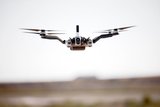
ASTRALiTe has demonstrated its two-in-one topo-bathy LiDAR system flying on the DJI Matrice 600 Pro UAS during three separate test flight missions.
Designed for topographic LiDAR surveys, the 5kg bathymetric scanning LiDAR system runs on its own self-contained battery, collecting centimetre-level bathymetric data.
In the first demonstration in Colorado, ASTRALiTe integrated its topo-bathy LiDAR system onto the Matrice 600 Pro for two 15 minute flights.
A second demonstration was conducted at high elevation in conjunction with the US Geological Survey in Kremmling, Colorado, at the confluence of the Colorado and Blue rivers. Four flights were conducted with flight times ranging between 10-12 minutes. River transects were made to document volume flow of the two rivers including depth profiles, vegetation mapping and underwater object detection.
A third set of demonstrations was conducted at the University of Hawaii’s Institute of Marine Biology on Coconut Island. Over three days the LiDAR was put to the test on the windward side of the island in conditions that included salt spray and significant surf. In these conditions, Matrice 600 Pro collected near-shore bathymetry, dune, inlet and lagoon profiles, and mapped underwater coral reef structures at centimetre-level resolution.


Although the Replicator initiative has made several accomplishments, there are still multiple gaps to plug across the US Department of Defense (DoD) and its services.

Cummings Aerospace presented its turbojet-powered Hellhound loitering munition at SOF Week 2025, offering a man-portable solution aligned with the US Army’s LASSO requirements.

PDW has revealed its Attritable Multirotor First Person View drone at SOF Week 2025, offering special operations forces a low-cost, rapidly deployable platform for strike and ISR missions, inspired by battlefield lessons from Ukraine.

Teledyne FLIR is highlighting the emerging requirements for 'recoverable and re-usable' loitering munitions across the contemporary operating environment during this week’s SOF Week conference in Tampa, Florida.

High-performance maritime industry player Kraken Technology Group, based in the UK, has used the SOF Week conference in Tampa, Florida this week to debut its K3 Scout uncrewed surface vessel (USV) to the North American market.
Red Cat and Palladyne AI recently conducted a cross-platform collaborative flight involving three diverse heterogeneous drones.

Connect with us on socials


