


What’s next for the Pentagon after the Replicator programme?
Although the Replicator initiative has made several accomplishments, there are still multiple gaps to plug across the US Department of Defense (DoD) and its services.

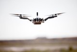
Terra Drone has successfully conducted a long-distance power line inspection for Electricity Generating Authority of Thailand and a power energy distributor in Poland and completed 12km power line mapping in a day, the company announced on 14 February.
The mission was carried out using a fixed wing RTK UAS equipped with a Sony RX1R II (full-frame 42-Mpix camera). The project aimed to research the distance between power lines and the surrounding vegetation and to create tree-trimming report. The inspection provided high-quality images of power line with about 1cm ground sampling distance and a detailed tree-trimming report.
Several flights with a maximum flight time of one hour per flight have completed a power line inspection with a distance of 50km in total. The company’s in-house 3D power line-recognition algorithm processes the data acquired from the flights, which is difficult to achieve with normal images, and measures the distance of obstacles to the power lines.
The acquired 3D mapping data and a detailed report will allow infrastructure inspection and management to be more accurate compared to the conventional visual inspection done by helicopter.


Although the Replicator initiative has made several accomplishments, there are still multiple gaps to plug across the US Department of Defense (DoD) and its services.

Cummings Aerospace presented its turbojet-powered Hellhound loitering munition at SOF Week 2025, offering a man-portable solution aligned with the US Army’s LASSO requirements.

PDW has revealed its Attritable Multirotor First Person View drone at SOF Week 2025, offering special operations forces a low-cost, rapidly deployable platform for strike and ISR missions, inspired by battlefield lessons from Ukraine.

Teledyne FLIR is highlighting the emerging requirements for 'recoverable and re-usable' loitering munitions across the contemporary operating environment during this week’s SOF Week conference in Tampa, Florida.

High-performance maritime industry player Kraken Technology Group, based in the UK, has used the SOF Week conference in Tampa, Florida this week to debut its K3 Scout uncrewed surface vessel (USV) to the North American market.
Red Cat and Palladyne AI recently conducted a cross-platform collaborative flight involving three diverse heterogeneous drones.

Connect with us on socials


