


What’s next for the Pentagon after the Replicator programme?
Although the Replicator initiative has made several accomplishments, there are still multiple gaps to plug across the US Department of Defense (DoD) and its services.

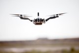
Kongsberg Geospatial has integrated its Iris UAS ground control station (GCS) with Survae’s digital asset management platform for geolocated video, imagery and data, the company announced on 5 April.
The integration will allow a single operator to manage the unified, real-time display and storage of video streams from multiple UAS being simultaneously managed by the Iris GCS.
Videos are meta-tagged and stored for near real-time analysis or for post-mission archival search of missions flown. This expanded post-mission retrieval and analysis capability will significantly reduce the workload for UAS operators.
The Kongsberg Geospatial Iris GCS provides real-time services to enable beyond visual line-of-sight operations including real-time calculation of aircraft separation and line-of-sight for data communications.
Eric Hesterman, CEO of Survae, said: 'It is clear that future operations will require a single operator to be able to manage the data collection from multiple aircraft. The Kongsberg Geospatial Iris GCS provides the ability to manage multiple aircraft and their sensors so Kongsberg is a very logical partner for us to provide an integrated solution for operators. Managing the data is the next challenge for the drone industry.'


Although the Replicator initiative has made several accomplishments, there are still multiple gaps to plug across the US Department of Defense (DoD) and its services.

Cummings Aerospace presented its turbojet-powered Hellhound loitering munition at SOF Week 2025, offering a man-portable solution aligned with the US Army’s LASSO requirements.

PDW has revealed its Attritable Multirotor First Person View drone at SOF Week 2025, offering special operations forces a low-cost, rapidly deployable platform for strike and ISR missions, inspired by battlefield lessons from Ukraine.

Teledyne FLIR is highlighting the emerging requirements for 'recoverable and re-usable' loitering munitions across the contemporary operating environment during this week’s SOF Week conference in Tampa, Florida.

High-performance maritime industry player Kraken Technology Group, based in the UK, has used the SOF Week conference in Tampa, Florida this week to debut its K3 Scout uncrewed surface vessel (USV) to the North American market.
Red Cat and Palladyne AI recently conducted a cross-platform collaborative flight involving three diverse heterogeneous drones.

Connect with us on socials


