


What’s next for the Pentagon after the Replicator programme?
Although the Replicator initiative has made several accomplishments, there are still multiple gaps to plug across the US Department of Defense (DoD) and its services.

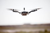
Chinese aerial-imaging company DJI and automated surveying solutions provider Datumate have launched the DJI-Datumate Site Survey Solution; a UAV, software and app package that automates and expedites site surveys. The release was announced on 11 October.
The system is designed to help infrastructure, inspection, construction and surveying companies generate a working model, analytics and plan and site visualisation.
The solution includes Datumate's DatuGram 3D photogrammetry software, DatuFly tablet app for automated aerial photography and DJI's UAV.
The DatuGram software converts ground and aerial images into geo-referenced 3D models and 2D maps. The DatuFly software generates a flight and image-taking plan for the DJI aircraft based on the best practice requirements of the 3D photogrammetry.
Paul Xu, DJI's director of enterprise solutions, said: ‘We believe that DJI-Datumate Site Survey Solutions offer a professional and cost-effective end-to-end solution for the surveying, infrastructure-mapping and inspection markets.’


Although the Replicator initiative has made several accomplishments, there are still multiple gaps to plug across the US Department of Defense (DoD) and its services.

Cummings Aerospace presented its turbojet-powered Hellhound loitering munition at SOF Week 2025, offering a man-portable solution aligned with the US Army’s LASSO requirements.

PDW has revealed its Attritable Multirotor First Person View drone at SOF Week 2025, offering special operations forces a low-cost, rapidly deployable platform for strike and ISR missions, inspired by battlefield lessons from Ukraine.

Teledyne FLIR is highlighting the emerging requirements for 'recoverable and re-usable' loitering munitions across the contemporary operating environment during this week’s SOF Week conference in Tampa, Florida.

High-performance maritime industry player Kraken Technology Group, based in the UK, has used the SOF Week conference in Tampa, Florida this week to debut its K3 Scout uncrewed surface vessel (USV) to the North American market.
Red Cat and Palladyne AI recently conducted a cross-platform collaborative flight involving three diverse heterogeneous drones.

Connect with us on socials


